-
o Natural gas field capacity utilization
levels of the 103 respondents increased on an annual basis, going
from 91.1 percent in 1994 to 93.3 percent in 1995. In comparison,
the estimated annual maximum feasible capacity utilization level
was reported to be 94.6 percent.
o During 1995, the annual field deliveries
of the 103 respondents increased by 1.7 percent. The respondents
also reported a 0.6 percent decline in their ability to inject
natural gas into the nation's gas transmission system. The increase
in annual gas deliveries was largely responsible for the 2.1 percentage
point increase in annual capacity utilization.
o In the last two surveys, the annual maximum
feasible capacity level was reported to be 94 and 94.6 percent,
respectively. This year's survey reports a maximum feasible capacity
factor of 94.6 percent, which is consistent with these prior estimates.
o Five survey regions reported a significant
increase in annual capacity utilization: the Offshore Gulf (+3.5
percentage points), the Permian Basin (+2.5 percentage points),
the Onshore Gulf (+2.2 percentage points), the Rocky Mtn./Pacific
Region (+1.7 percentage points), and the East/North Central (+1.2
percentage points). In contrast, the other two survey regions
posted only slight declines in annual capacity utilization: the
Anadarko Basin (-0.7 percentage points) and the San Juan Basin
(-0.4 percentage points).
o Just as 1995 annual capacity utilization
increased, so too did December capacity utilization. Lower-48
1995 December capacity utilization level was 1.5 percentage points
higher than the December 1994 utilization level. Five regions
-- the Onshore Gulf, Permian Basin, San Juan Basin, Anadarko Basin,
and the Rocky Mtn./Pacific Region -- all reported December 1995
utilization levels above the December maximum feasible capacity
level. This indicates that these five regions were operating
at maximum productive capacity.
METHODOLOGY
SURVEY
COVERAGE OF LOWER-48 NATURAL GAS PRODUCTION
SURVEY RESULTS FOR THE U.S.
LOWER-48 STATES
I. Natural Gas Field Productive Capacity
A. Changes In Connected Gas Field Capacity Between January 1, 1995 and January 1, 1996
SCHEDULE 1 - RESULTS OF THE
1996 NGSA NATURAL GAS PRODUCER DELIVERABILITY SURVEY:
SURVEY COVERAGE RELATIVE TO EIA 1994 PRODUCTION
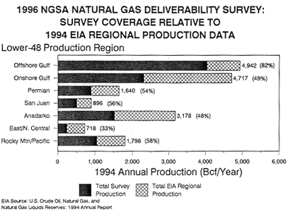
| SURVEY REGIONS | ANNUAL 1994 SURVEY PRODUCTION
| 1994 EIA GAS PRODUCTION (Bcf/Year) | PERCENT OF EIA GAS PRODUCTION | |||
|---|---|---|---|---|---|---|
| 1 OFFSHORE GULF | 11,086 | 4,046 | 4,942 | 81.9% | ||
| 2 ONSHORE GULF | 6,328 | 2,310 | 4,717 | 49.0% | ||
| 3 PERMIAN BASIN | 2,436 | 889 | 1,640 | 54.2% | ||
| 4 SAN JUAN BASIN | 1,373 | 501 | 896 | 55.9% | ||
| 5 ANADARKO | 4,173 | 1,523 | 3,178 | 47.9% | ||
| 6 EAST/NORTH CENTRAL | 648 | 236 | 718 | 32.9% | ||
| 7 ROCKY MOUNTAIN/PACIFIC | 2,861 | 1,044 | 1,798 | 58.1% | ||
TOTAL LOWER-48 | 28,903 | 10,550 | 17,889 | 59.0% | ||
ONSHORE & OFFSHORE GULF REGIONS COMBINED | 17,414 | 6,356 | 9,659 | 65.8% | ||
SCHEDULE 2 - RESULTS OF THE
1996 NGSA NATURAL GAS PRODUCER DELIVERABILITY SURVEY:
CONNECTED & UNCONNNECTED NATURAL GAS PRODUCTIVE FIELD CAPACITY
(On A Dry Gas Basis)
CONNECTED NATURAL GAS PRODUCTIVE FIELD CAPACITY
(MMcf/Day)| SURVEY REGION | JAN. 1st 1995 | JAN. 1st 1996 | CHANGE IN MAGNITUDE | PERCENT CHANGE |
|---|---|---|---|---|
| 1 OFFSHORE GULF | 12,532 | 12,456 | (77) | -0.6% |
| 2 ONSHORE GULF | 6,837 | 6,722 | (115) | -1.7% |
| 3 PERMIAN BASIN | 2,637 | 2,573 | (64) | -2.4% |
| 4 SAN JUAN BASIN | 1,429 | 1,401 | (28) | -2.0% |
| 5 ANADARKO BASIN | 4,390 | 4,230 | (161) | -3.7% |
| 6 EAST/N. CENTRAL | 689 | 776 | 86 | 12.5% |
| 7 ROCKY MTN/PACIFIC | 3,201 | 3,364 | 164 | 5.1% |
| TOTAL | 31,715 | 31,521 | (194) | -0.6% |
UNCONNNECTED NATURAL GAS PRODUCTIVE FIELD CAPACITY
(MMcf/Day)| SURVEY REGION | JAN. 1st 1995 | JAN. 1st 1996 | CHANGE IN MAGNITUDE | PERCENT CHANGE |
|---|---|---|---|---|
| 1 OFFSHORE GULF | 1,159 | 994 | (165) | -14.3% |
| 2 ONSHORE GULF | 281 | 112 | (169) | -60.1% |
| 3 PERMIAN BASIN | 28 | 15 | (13) | -46.0% |
| 4 SAN JUAN BASIN | 9 | 25 | 16 | 168.5% |
| 5 ANADARKO BASIN | 68 | 50 | (18) | -26.1% |
| 6 EAST/N. CENTRAL | 18 | 17 | (1) | -3.4% |
| 7 ROCKY MTN/PACIFIC | 93 | 54 | (39) | -42.0% |
| TOTAL | 31,715 | 1,266 | (368) | -23.5% |
TOTAL CONNECTED & UNCONNNECTED NATURAL GAS PRODUCTIVE FIELD CAPACITY
(MMcf/Day)| SURVEY REGION | JAN. 1st 1995 | JAN. 1st 1996 | CHANGE IN MAGNITUDE | PERCENT CHANGE |
|---|---|---|---|---|
| 1 OFFSHORE GULF | 13,692 | 13,450 | (242) | -1.8% |
| 2 ONSHORE GULF | 7,117 | 6,833 | (284) | -4.0% |
| 3 PERMIAN BASIN | 2,665 | 2,588 | (76) | -2.9% |
| 4 SAN JUAN BASIN | 1,448 | 1,425 | (13) | -0.9% |
| 5 ANADARKO BASIN | 4,458 | 4,279 | (178) | -4.0% |
| 6 EAST/N. CENTRAL | 707 | 793 | 86 | 12.1% |
| 7 ROCKY MTN/PACIFIC | 3,293 | 3,418 | 125 | 3.8% |
| TOTAL | 33,369 | 32,786 | (582) | -1.7% |
UNCONNECTED CAPACITY AS A PERCENT OF TOTAL CAPACITY
(Percent)| SURVEY REGION | JAN. 1st 1995 | JAN. 1st 1996 |
|---|---|---|
| 1 OFFSHORE GULF | 8.5% | 7.4% |
| 2 ONSHORE GULF | 3.9% | 1.6% |
| 3 PERMIAN BASIN | 1.0% | 0.6% |
| 4 SAN JUAN BASIN | 0.6% | 1.7% |
| 5 ANADARKO BASIN | 1.5% | 1.2% |
| 6 EAST/N. CENTRAL | 2.5% | 2.1% |
| 7 ROCKY MTN/PACIFIC | 2.8% | 1.6% |
| TOTAL | 5.0% | 3.9% |
B. Changes In Connected And Unconnected
Gas Field Capacity Between January 1, 1995 and January 1, 1996
II. Connected Gas Field Capacity Utilization
Levels
A. Productive Capacity Utilization Levels
For 1994 And 1995
SCHEDULE 3 - RESULTS OF THE
1996 NGSA NATURAL GAS PRODUCER DELIVERABILITY SURVEY:
ANNUAL CONNECTED CAPACITY UTILIZATION LEVELS
(On A Dry Gas Basis)
CONNECTED NATURAL GAS FIELD CAPACITY
(MMcf/Day)| SURVEY REGION | JAN. 1st 1995 | JAN. 1st 1996 | CHANGE IN MAGNITUDE | PERCENT CHANGE |
|---|---|---|---|---|
| 1 OFFSHORE GULF | 12,532 | 12,456 | (77) | -0.6% |
| 2 ONSHORE GULF | 6,837 | 6,722 | (115) | -1.7% |
| 3 PERMIAN BASIN | 2,637 | 2,573 | (64) | -2.4% |
| 4 SAN JUAN BASIN | 1,429 | 1,401 | (28) | -2.0% |
| 5 ANADARKO BASIN | 4,390 | 4,230 | (161) | -3.7% |
| 6 EAST/N. CENTRAL | 689 | 776 | 86 | 12.5% |
| 7 ROCKY MTN/PACIFIC | 3,201 | 3,364 | 164 | 5.1% |
| TOTAL | 31,715 | 31,521 | (194) | -0.6% |
ANNUAL NATURAL GAS FIELD DELIVERIES
(MMcf/Day)| SURVEY REGION | ANNUAL 1994 | ANNUAL 1995 | CHANGE IN MAGNITUDE | PERCENT CHANGE |
|---|---|---|---|---|
| 1 OFFSHORE GULF | 11,086 | 11,455 | 369 | -3.3% |
| 2 ONSHORE GULF | 6,328 | 6,370 | 42 | -0.7% |
| 3 PERMIAN BASIN | 2,436 | 2,441 | 5 | -0.2% |
| 4 SAN JUAN BASIN | 1,373 | 1,341 | (32) | -2.4% |
| 5 ANADARKO BASIN | 4,173 | 3,989 | (183) | -4.4% |
| 6 EAST/N. CENTRAL | 648 | 739 | 91 | 14.0% |
| 7 ROCKY MTN/PACIFIC | 2,861 | 3,064 | 203 | 7.1% |
| TOTAL | 28,903 | 29,397 | 494 | 1.7% |
ANNUAL GAS FIELD CAPACITY UTILIZATION
(Percent)| SURVEY REGION | ANNUAL 1994 | ANNUAL 1995 | CHANGE IN PERCENT | ANNUAL MAXIMUM FEASIBLE CAPACITY LEVEL |
|---|---|---|---|---|
| 1 OFFSHORE GULF | 88.5% | 92.0% | 3.5 | 93.0% |
| 2 ONSHORE GULF | 92.6% | 94.8% | 2.2 | 95.7% |
| 3 PERMIAN BASIN | 92.4% | 94.8% | 2.5 | 95.2% |
| 4 SAN JUAN BASIN | 96.1% | 95.7% | -0.4 | 95.3% |
| 5 ANADARKO BASIN | 95.0% | 94.3% | -0.7 | 94.8% |
| 6 EAST/N. CENTRAL | 94.0% | 95.2% | 1.2 | 95.7% |
| 7 ROCKY MTN/PACIFIC | 89.4% | 91.1% | 1.7 | 96.7% |
| TOTAL | 91.1% | 93.3% | 2.1 | 94.5% |
| ONSHORE/OFFSHORE GULF REGIONS COMBINED | 89.9% | 92.9% | 3.0 | 93.9% |
B. Comparing Annual Capacity Utilization
To The Annual Maximum Feasible Capacity Utilization
C. Comparing December Capacity Utilization
Levels To The December Maximum Feasible Capacity Utilization
SCHEDULE 4 - RESULTS OF THE
1996 NGSA NATURAL GAS PRODUCER DELIVERABILITY SURVEY:
DECEMBER CONNECTED CAPACITY UTILIZATION LEVELS
(On A Dry Gas Basis)
CONNECTED NATURAL GAS FIELD CAPACITY
(MMcf/Day)| SURVEY REGION | JAN. 1st 1995 | JAN. 1st 1996 | CHANGE IN MAGNITUDE | PERCENT CHANGE |
|---|---|---|---|---|
| 1 OFFSHORE GULF | 12,532 | 12,456 | (77) | -0.6% |
| 2 ONSHORE GULF | 6,837 | 6,722 | (115) | -1.7% |
| 3 PERMIAN BASIN | 2,637 | 2,573 | (64) | -2.4% |
| 4 SAN JUAN BASIN | 1,429 | 1,401 | (28) | -2.0% |
| 5 ANADARKO BASIN | 4,390 | 4,230 | (161) | -3.7% |
| 6 EAST/N. CENTRAL | 689 | 776 | 86 | 12.5% |
| 7 ROCKY MTN/PACIFIC | 3,201 | 3,364 | 164 | 5.1% |
| TOTAL | 31,715 | 31,521 | (194) | -0.6% |
DECEMBER NATURAL GAS FIELD DELIVERIES
(MMcf/Day)| SURVEY REGION | DEC. 1994 | DEC. 1995 | CHANGE IN MAGNITUDE | PERCENT CHANGE |
|---|---|---|---|---|
| 1 OFFSHORE GULF | 11,404 | 11,632 | 228 | 2.0% |
| 2 ONSHORE GULF | 6,512 | 6,548 | 36 | 0.5% |
| 3 PERMIAN BASIN | 2,587 | 2,596 | 9 | 0.3% |
| 4 SAN JUAN BASIN | 1,384 | 1,385 | 1 | 0.0% |
| 5 ANADARKO BASIN | 4,417 | 4,187 | (231) | -5.2% |
| 6 EAST/N. CENTRAL | 674 | 738 | 63 | 9.4% |
| 7 ROCKY MTN/PACIFIC | 3,120 | 3,292 | 172 | 5.5% |
| TOTAL | 30,099 | 30,377 | 278 | 0.9% |
DECEMBER GAS FIELD CAPACITY UTILIZATION
(Percent)| SURVEY REGION | DEC. 1994 | DEC. 1995 | CHANGE IN PERCENT | ANNUAL MAXIMUM FEASIBLE CAPACITY LEVEL |
|---|---|---|---|---|
| 1 OFFSHORE GULF | 91.0% | 93.4% | 2.4 | 94.0% |
| 2 ONSHORE GULF | 95.3% | 97.4% | 2.2 | 96.3% |
| 3 PERMIAN BASIN | 98.1% | 100.9% | 2.8 | 95.6% |
| 4 SAN JUAN BASIN | 96.9% | 98.9% | 2.0 | 97.6% |
| 5 ANADARKO BASIN | 100.6% | 99.0% | -1.6 | 96.5% |
| 6 EAST/N. CENTRAL | 97.8% | 95.1% | -2.7 | 97.1% |
| 7 ROCKY MTN/PACIFIC | 97.5% | 97.9% | 0.4 | 97.3% |
| TOTAL | 94.9% | 96.4% | 1.5 | 95.5% |
| ONSHORE/OFFSHORE GULF REGIONS COMBINED | 92.5% | 94.8% | 2.3 | 94.8% |
FIGURE 4
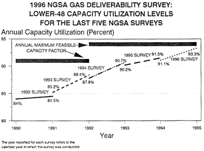
FIGURE 5

III. Comparing Capacity Utilization Levels
For The Last Five NGSA Surveys
SCHEDULE 5 - RESULTS OF THE
1996 NGSA NATURAL GAS PRODUCER DELIVERABILITY SURVEY:
COMPARABLE ANNUAL CONNECTED CAPACITY UTILIZATION LEVELS
FOR THE LAST FIVE NGSA SURVEYS
| 1992 SURVEY | ACTUAL CAPACITY UTILIZATION | ANNUAL MAXIMUM FEASIBLE CAPACITY LEVEL | SPARE CAPACITY IN LATEST YEAR 1/ | |||||
|---|---|---|---|---|---|---|---|---|
| 1990 | 1991 | 1992 | 1993 | 1994 | 1995 | |||
| 1 OFFSHORE GULF | 81.9% | 81.5% | - | - | - | - | 92.2% | 10.7% |
| 2 ONSHORE GULF | 87.2% | 87.4% | - | - | - | - | 92.5% | 5.1% |
| 3&4 PERMIAN/SAN JUAN | 86.7% | 89.2% | - | - | - | - | 91.2% | 2.0% |
| 5 ANADARKO BASIN | 83.6% | 83.4% | - | - | - | - | 90.0% | 6.6% |
| 6 EAST/N. CENTRAL | 86.3% | 92.3% | - | - | - | - | 92.8% | 0.5% |
| 7 ROCKY MTN/PACIFIC | 81.3% | 84.3% | - | - | - | - | 91.2% | 6.9% |
| TOTAL | 84.0% | 84.5% | - | - | - | - | 91.7% | 7.2% |
| 1993 SURVEY | ACTUAL CAPACITY UTILIZATION | ANNUAL MAXIMUM FEASIBLE CAPACITY LEVEL | SPARE CAPACITY IN LATEST YEAR 1/ | |||||
|---|---|---|---|---|---|---|---|---|
| 1990 | 1991 | 1992 | 1993 | 1994 | 1995 | |||
| 1 OFFSHORE GULF | - | 84.0% | 88.5% | - | - | - | 92.6% | 4.1% |
| 2 ONSHORE GULF | - | 87.4% | 90.4% | - | - | - | 93.4% | 3.0% |
| 3&4 PERMIAN/SAN JUAN | - | 86.6% | 88.4% | - | - | - | 92.6% | 4.2% |
| 5 ANADARKO BASIN | - | 82.9% | 84.4% | - | - | - | 90.1% | 5.7% |
| 6 EAST/N. CENTRAL | - | 94.6% | 93.9% | - | - | - | 94.9% | 1.0% |
| 7 ROCKY MTN/PACIFIC | - | 84.6% | 88.7% | - | - | - | 93.5% | 4.8% |
| TOTAL | - | 85.2% | 88.4% | - | - | - | 92.5% | 4.1% |
| 1994 SURVEY | ACTUAL CAPACITY UTILIZATION | ANNUAL MAXIMUM FEASIBLE CAPACITY LEVEL | SPARE CAPACITY IN LATEST YEAR 1/ | |||||
|---|---|---|---|---|---|---|---|---|
| 1990 | 1991 | 1992 | 1993 | 1994 | 1995 | |||
| 1 OFFSHORE GULF | - | - | 88.6% | 88.8% | - | - | 93.8% | 5.0% |
| 2 ONSHORE GULF | - | - | 89.2% | 93.9% | - | - | 94.4% | 0.5% |
| 3&4 PERMIAN/SAN JUAN | - | - | 84.9% | 92.2% | - | - | 94.4% | 2.2% |
| 5 ANADARKO BASIN | - | - | 85.0% | 88.2% | - | - | 91.4% | 3.2% |
| 6 EAST/N. CENTRAL | - | - | 93.1% | 93.8% | - | - | 95.8% | 2.0% |
| 7 ROCKY MTN/PACIFIC | - | - | 89.0% | 92.7% | - | - | 96.0% | 3.3% |
| TOTAL | - | - | 87.8% | 90.7% | - | - | 93.9% | 3.2% |
| 1995 SURVEY | ACTUAL CAPACITY UTILIZATION | ANNUAL MAXIMUM FEASIBLE CAPACITY LEVEL | SPARE CAPACITY IN LATEST YEAR 1/ | |||||
|---|---|---|---|---|---|---|---|---|
| 1990 | 1991 | 1992 | 1993 | 1994 | 1995 | |||
| 1 OFFSHORE GULF | - | - | - | 87.5% | 90.3% | - | 94.5% | 4.2% |
| 2 ONSHORE GULF | - | - | - | 93.2% | 93.1% | - | 95.2% | 2.1% |
| 3&4 PERMIAN/SAN JUAN | - | - | - | 84.9% | 92.2% | - | 94.4% | 2.2% |
| 5 ANADARKO BASIN | - | - | - | 89.0% | 92.9% | - | 93.3% | 0.4% |
| 6 EAST/N. CENTRAL | - | - | - | 93.6% | 91.7% | - | 94.9% | 3.2% |
| 7 ROCKY MTN/PACIFIC | - | - | - | 91.8% | 89.6% | - | 95.6% | 6.0% |
| TOTAL | - | - | - | 90.2% | 91.5% | - | 94.6% | 3.1% |
| 1996 SURVEY | ACTUAL CAPACITY UTILIZATION | ANNUAL MAXIMUM FEASIBLE CAPACITY LEVEL | SPARE CAPACITY IN LATEST YEAR 1/ | |||||
|---|---|---|---|---|---|---|---|---|
| 1990 | 1991 | 1992 | 1993 | 1994 | 1995 | |||
| 1 OFFSHORE GULF | - | - | - | - | 88.5% | 92.0% | 93.0% | 1.0% |
| 2 ONSHORE GULF | - | - | - | - | 92.6% | 94.8% | 95.7% | 0.9% |
| 3&4 PERMIAN/SAN JUAN | - | - | - | - | 93.7% | 95.1% | 95.2% | 0.1% |
| 5 ANADARKO BASIN | - | - | - | - | 95.0% | 94.3% | 94.8% | 0.5% |
| 6 EAST/N. CENTRAL | - | - | - | - | 94.0% | 95.2% | 95.7% | 0.5% |
| 7 ROCKY MTN/PACIFIC | - | - | - | - | 89.4% | 91.1% | 96.7% | 5.6% |
| TOTAL | - | - | - | - | 91.1% | 93.3% | 94.6% | 1.3% |
1/ Equals the Annual Max. Feasible Capacity Factor minus the latest period's Annual Utilization Level.
APPENDIX A
SURVEY RESPONDENTS INCLUDED
IN THE NGSA DELIVERABILITY SURVEY RESULTS
|
1. Alamco Inc. 2. American Exploration Co. 3. Amoco Production Company 4. Anadarko Petroleum Corp. 5. Atlantic Oil Corporation 6. Badger Oil Corporation 7. Bright & Company 8. Browning Oil Company, Inc. 9. Burk Royalty Co. 10. Cabot Oil & Gas Corp. 11. Callon Petroleum Operating Co. 12. Chevron U.S.A. Production Co. 13. Clinton Gas Systems 14. CMS NOMECO Oil & Gas Co. 15. CNG Producing Company 16. Coastal Oil & Gas Corp. 17. Cockrell Oil Corp. 18. Columbia Natural Resources, Inc. 19. Columbus Energy Corp. 20. Conoco Inc. 21. Continental Resources, Inc. 22. Crawley Petroleum Corp. 23. CXY Energy Inc. 24. Devon Energy Corp. 25. Dorchester Hugoton Ltd. 26. Dugan Production Corp. 27. Eastern America Energy Corp. 28. Energy Development Corp. 29. Enex Resources Corp. 30. Enron Oil & Gas Co. 31. Ensign Oil & Gas Inc. 32. Exxon Company U.S.A. 33. Forest Oil Corporation 34. Giant Expl. & Prod. Co. 35. Great River Oil & Gas Corp. 36. Greenhill Petroleum Corporation 37. Hexagon Oil & Gas Inc. 38. HS Resources Inc. 39. J-W Operating Co. 40. John H. Hendrix Corp. 41. John H. Young, Inc. 42. Kamlok Oil & Gas, Inc. 43. Kelley Oil & Gas Corp. 44. Kerns Oil & Gas Inc. 45. Kerr-McGee Corp. 46. K.N. Production Company 47. Luff Exploration Company 48. Maguire Oil Company 49. Maralo Inc. 50. Marathon Oil Company 51. Meridian Exploration Corp. 52. Mesa, Inc. |
53. Michael Petroleum Corporation 54. Mitchell Energy Corporation 55. Mobil Natural Gas Inc. 56. Murphy Exploration & Production Co. 57. Nearburg Producing Company 58. Newfield Exploration Co. 59. North American Resources Company 60. ONEOK Inc. 61. ORYX Energy Corp. 62. Oxford Oil Company 63. Oxley Petroleum 64. OXY USA Inc. 65. PetroCorp. Inc. 66. Petroleum Development Corp. 67. Phillips Petroleum Corp. 68. P.N.G. Operating Co. 69. Pogo Producing Company 70. River Gas Corporation 71. Seagull Energy E&P Inc. 72. Seneca Resources Corp. 73. Shell Oil Company 74. Slawson Exploration Co., Inc. 75. Southwestern Energy Corp. 76. St. Mary Operating Co. 77. Sullivan and Company 78. Swift Energy Corp. 79. Taurus Exploration, Inc. 80. Tennessee Gas Pipeline Co. 81. Tesoro Expl. & Prod. Co. 82. Texaco Exploration & Production Inc. 83. The Louisiana Land & Expl. Co. 84. The Wiser Oil Company 85. Thums Long Beach Company 86. Tidelands Oil Production Co. 87. Toklan Oil & Gas Corp. 88. Tom Brown Inc. 89. Torch Energy Advisors 90. Trans Texas Gas Corp. 91. Total Minatome Corp. 92. U.S. Department of Energy 93. U.S. Department of Energy-NPOSR-CUW 94. Union Oil of California 95. Union Pacific Resources 96. Vastar Resources, Inc. 97. Vessels Energy Inc. 98. Wagner & Brown Ltd. 99. Walter Oil & Gas Corporation 100. Western Gas Resources, Inc. 101. Williford Energy Company 102. Williston Basin Interstate P/L Co. 103. Yates Petroleum Corp. |
APPENDIX B
DEFINITION OF NGSA SURVEY
REGIONS
- 1. Offshore Gulf Coast:
Includes all the offshore Gulf field deliveries and productive
capacity, both in state and federal jurisdictions, for the states
of Alabama, Florida, Louisiana, Mississippi, and Texas.
2. Onshore Gulf Coast:
Includes all onshore field deliveries and productive capacity
for Alabama, Florida, Georgia, Louisiana, Mississippi, and Texas
Railroad Districts: 1, 2, 3, 4, 5, & 6.
3. Permian Basin:
Includes 15 eastern counties of New Mexico (Chaves, Colfax, Curry,
De Baca, Eddy, Guadalupe, Harding, Lea, Lincoln, Mora, Otero,
Quay, Roosevelt, San Miguel, and Union) plus the Texas Railroad
Districts: 7B, 7C, 8, and 8A.
4. San
Juan Basin: Includes the 18 western counties of New Mexico
(Bernalillo, Catron, Cibola, Dona Ana, Grant, Hidalgo, Los Alamos,
Luna, McKinley, Rio Arriba, Sandoval, San Juan, Santa Fe, Sierra,
Socorro, Taos, Torrance, and Valencia).
5. Anadarko Basin:
Includes Arkansas, Kansas, Oklahoma, and Texas Railroad Districts:
9 and 10.
6. East/North Central:
All onshore and offshore gas field deliveries and productive
capacity for the states of: Delaware, Illinois, Indiana, Iowa,
Kentucky, Maryland, Michigan, Minnesota, Missouri, New Jersey,
New York, North Carolina, Ohio, Pennsylvania, South Carolina,
Tennessee, Virginia, West Virginia, and Wisconsin.
7. Rocky Mountain/Pacific:
Includes both onshore and offshore field deliveries and productive
capacity associated with: Arizona, California, Colorado, Idaho,
Montana, Nebraska, Nevada, North Dakota, Oregon, South Dakota,
Utah, Washington, and Wyoming.
8. Total U.S. Lower-48:
Includes both onshore and offshore field deliveries and productive
capacity for all the regions listed.
APPENDIX C
FOR THE 1996 NATURAL GAS SUPPLY ASSOCIATION
SURVEY ON NATURAL GAS FIELD DELIVERIES
WELLHEAD PRODUCTIVE CAPACITY:
Connected Field Capacity (a.k.a.
Connected Capacity)
Unconnected Field Capacity (a.k.a.
Unconnected Capacity)
ANNUAL NATURAL GAS FIELD DELIVERIES:
DECEMBER NATURAL GAS FIELD DELIVERIES:
ANNUAL PRODUCTIVE CAPACITY UTILIZATION:
DECEMBER PRODUCTIVE CAPACITY UTILIZATION:
ANNUAL MAXIMUM FEASIBLE CAPACITY UTILIZATION
LEVELS
DECEMBER MAXIMUM FEASIBLE CAPACITY UTILIZATION
LEVELS
APPENDIX D, TABLE 1
1994 RATIO OF REGIONAL DRY GAS PRODUCTION TO WET GAS PRODUCTION
BY DEPARTMENT OF ENERGY PRODUCTION DISTRICT
| REGION | WET GAS (Bcf) | DRY GAS (Bcf) | WET/DRY RATIO |
|---|---|---|---|
| ALABAMA | 397 | 391 | 0.985 |
| ALASKA | 454 | 423 | 0.932 |
| ARKANSAS | 186 | 186 | 1.000 |
| CALIFORNIA | 255 | 244 | 0.957 |
| ---->COASTAL ONSHORE | 17 | 16 | 0.941 |
| ---->LOS ANGELES ONSHORE | 9 | 9 | 1.000 |
| ---->SAN JOAQUIN ONSHORE | 223 | 213 | 0.955 |
| ---->STATE OFFSHORE | 6 | 6 | 1.000 |
| COLORADO | 466 | 447 | 0.959 |
| FLORIDA | 8 | 7 | 0.959 |
| KANSAS | 710 | 671 | 0.945 |
| KENTUCKY | 67 | 64 | 0.955 |
| LOUISIANA | 1,512 | 1,453 | 0.961 |
| ---->NORTH | 335 | 328 | 0.979 |
| ---->SOUTH ONSHORE | 1,030 | 981 | 0.952 |
| ---->STATE OFFSHORE | 147 | 144 | 0.980 |
| MICHIGAN | 156 | 150 | 0.962 |
| MISSISSIPPI | 83 | 82 | 0.988 |
| MONTANA | 50 | 49 | 0.980 |
| NEW MEXICO | 1,449 | 1,362 | 0.940 |
| ---->EAST | 515 | 466 | 0.905 |
| ---->WEST | 934 | 896 | 0.959 |
| NEW YORK | 21 | 21 | 1.000 |
| NORTH DAKOTA | 53 | 47 | 0.887 |
| OHIO | 119 | 119 | 1.000 |
| OKLAHOMA | 1,827 | 1,721 | 0.942 |
| PENNSYLVANIA | 142 | 141 | 0.993 |
| TEXAS | 5,154 | 4775 | 0.926 |
| ---->RRC DIST #1 | 102 | 97 | 0.951 |
| ---->RRC DIST #2 ONSHORE | 242 | 224 | 0.926 |
| ---->RRC DIST #3 ONSHORE | 651 | 600 | 0.922 |
| ---->RRC DIST #4 ONSHORE | 1,278 | 1,226 | 0.959 |
| ---->RRC DIST #5 | 191 | 185 | 0.969 |
| ---->RRC DIST #6 | 630 | 596 | 0.946 |
| ---->RRC DIST #7B | 77 | 65 | 0.844 |
| ---->RRC DIST #7C | 368 | 334 | 0.908 |
| ---->RRC DIST #8 | 760 | 688 | 0.905 |
| ---->RRC DIST #8A | 112 | 87 | 0.777 |
| ---->RRC DIST #9 | 119 | 100 | 0.840 |
| ---->RRC DIST #10 | 550 | 500 | 0.909 |
| ---->STATE OFFSHORE | 74 | 73 | 0.986 |
| UTAH | 198 | 184 | 0.929 |
| VIRGINIA | 51 | 51 | 1.000 |
| WEST VIRGINIA | 182 | 172 | 0.945 |
| WYOMING | 814 | 780 | 0.958 |
| FEDERAL OFFSHORE | 4,845 | 4,772 | 0.985 |
| ---->PACIFIC COAST | 48 | 47 | 0.979 |
| ---->GULF OF MEXICO(LA) | 3,505 | 3,440 | 0.981 |
| ---->GULF OF MEXICO(TX) | 1,292 | 1,285 | 0.995 |
| MISCELLANEOUS | 11 | 10 | 0.909 |
| U.S. TOTAL | 19,210 | 18,322 | 0.954 |
Source:"Advance Summary U.S. Crude Oil, Natural Gas, And Natural Gas Liquids Reserves: 1994 Annual Report", Energy Information Administration, DOE/EIA-0216(94) August, 1995, Tables 3 & 4.
APPENDIX D, TABLE 2
1994 RATIO OF REGIONAL DRY GAS PRODUCTION TO WET GAS PRODUCTION
BY NGSA SURVEY REGION
| REGION | WET GAS (Bcf) | DRY GAS (Bcf) | WET/DRY RATIO |
|---|---|---|---|
| 1 OFFSHORE GULF | 5,108 | 4,942 | 0.985 |
| 2 ONSHORE GULF | 4,947 | 4,717 | 0.954 |
| 3 PERMIAN BASIN | 1,832 | 1,640 | 0.895 |
| 4 SAN JUAN BASIN | 934 | 896 | 0.959 |
| 5 ANADARKO BASIN | 3,392 | 3,178 | 0.937 |
| 6 EAST/N. CENTRAL | 738 | 718 | 0.973 |
| 7 ROCKY MTN/PACIFIC | 1,884 | 1,798 | 0.954 |
| TOTAL LOWER-48 | 18,745 | 17,889 | 0.954 |
| ALASKA & MISCELLANEOUS | 465 | 433 | 0.931 |
| U.S. TOTAL | 19,210 | 18,322 | 0.954 |
Source: Appendix D, Table 1.
Notes:
- Additional surveys had been received but were not included in the final survey tabulation due either to: 1) an incomplete survey response, or 2) data inconsistencies or errors which could not be resolved by the accountants.
- "Wet" gas refers to the presence of natural gas liquids (e.g., butane, propane, ethane, etc.) in the gas stream; it does not refer to the water content of the gas. In contrast, "dry" natural gas refers to the absense of natural gas liquids in the gas stream. Both "wet" and "dry" gas has already been stripped of residual water.
- The maximum feasible capacity utilization factor is a measure of the historic availability of wellhead gas production, as experienced over the last five to ten years. Consequently, utilization levels for any particular survey period can exceed the values reported for this historic measure.
- Source: "Monthly Energy Review", Energy Information Administration, DOE/EIA-0035(96/01), January 1996, Table 1.11, page 18.
- Gas withdrawls from storage in December 1994 equaled 465 Bcf and in December 1995 equaled 618 Bcf. In contrast, total U.S. dry gas production for December 1994 and December 1995 equaled 1,655 Bcf and 1,644 Bcf, respectively. (Source: "Natural Gas Monthly", Energy Information Administration, DOE/EIA-0130(96/06), June 1996, Table 2, page 8.
- "Wet" gas refers to the presence of natural gas liquids (e.g., butane, propane, ethane, etc.) in the gas stream; it does not refer to the water content of the gas. In contrast, "dry" natural gas refers to the absense of natural gas liquids in the gas stream. Both "wet" and "dry" gas has already been stripped of residual water.
 |
 |
 |
 |
 |
 |
 |
 |
 |
 |
This page was last updated August 31, 1997