|
|
|
|
|
|
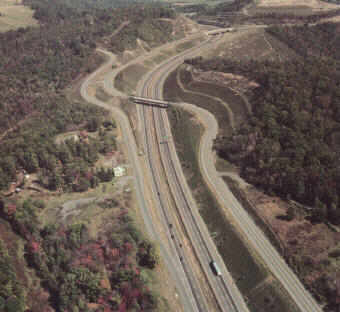
I-68:
Wolfe Mill to M.V. Smith Road
In the mid-1980s, there was a 19-mile gap in the 83 mile long Maryland portion of the National Freeway (now I-68) through Western Maryland. We were the prime consultant for the project planning study to select an alternative to complete the gap. Challenges included mountainous terrain, impacts to communities, sensitive environmental areas (e.g., shale barrens, trout streams, large contiguous forests) and historic sites. Our services included environmental analyses (e.g., socioeconomic, natural environment, air, noise), development of alternatives, preparation of environmental documents, and coordination with the public and regulatory agencies. The selected alternative provided not only a 4-lane full access controlled highway, but also a 2-lane service road for local traffic and access to adjoining properties. The benefit of this project to the community and state is evidence by the fact that in a 5-year period 1980-1984, the then existing road carried about 8,000 vehicles per day and experienced thirteen fatal accidents; during the 5 year period 1993-1997, I-68 carried about 13,000 vehicles per day but only had four fatal accidents. Likewise, the total number of accidents decreased, from 297 to 225, even though traffic increased by 62%. In addition, I-68 has contributed to the economic development of Western Maryland, particularly in Cumberland, Frostburg and Deep Creek Lake area.
|