P.O. Box 570 · Fulton, Maryland 20759 · E-mail: Info@maps-charts.com · Call Toll Free 1-888-513-MAPS
P.O. Box 570 · Fulton, Maryland 20759 · E-mail: Info@maps-charts.com · Call Toll Free 1-888-513-MAPS |
|||||
|---|---|---|---|---|---|
| How to Purchase | Age of Exploration | Historical Maps | Europe | North/South America | Globes |
| Curency Conversion Table | Prints, Books Photos Misc | Retail Outlet | Whistler Prints | Hot Links | Home |
(Click on images to view in full page)
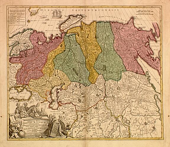
570.31 Generalis Totius Imperii Russorum, Russia, Augsburg, c1750, Johann Baptist Homann
 A
very colorerful map of Russia by the great Homann. The geography includes
Scandinavia, Kamtchatka and parts of China. A decorative title cartouche with
figures, one holding a globe. Sailing ship is noted at the top left. A good dark
impression with some very minor age-toning along the center fold. The overall
condiiton is very good, measures approximately (18.9" x 21.9").$
200.00 ($10.50 shipping/ handling/ ins.)
A
very colorerful map of Russia by the great Homann. The geography includes
Scandinavia, Kamtchatka and parts of China. A decorative title cartouche with
figures, one holding a globe. Sailing ship is noted at the top left. A good dark
impression with some very minor age-toning along the center fold. The overall
condiiton is very good, measures approximately (18.9" x 21.9").$
200.00 ($10.50 shipping/ handling/ ins.)
570.13 France, Artesia Comitatu - Artois, Amsterdam, c1592, Willem Blaeu
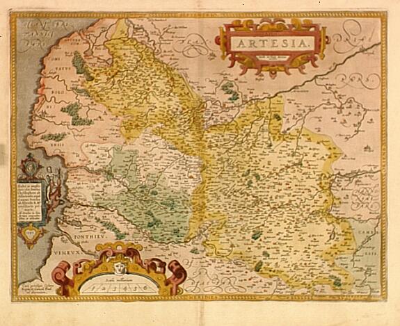 This
striking 16th century rendering was prepared by Jacob Suron whose manuscript map
of Artois brought him 36 Livres from Charles V in 1554. A great deal of
security surrounded the map and for that reason it was not published. Only after
1579 when Antwerp was independent for a short time, Ortelius used the map in his
atlas publication [map 73] and then only briefly. From that issue others used
the map for their publishig. The map is in very god condition considering it is
over four hundred years old. In original colors, printed on heavy stock it
measures approximately (15.1" x 19.7")$
302.00 ($10.50 shipping/ handling/ ins.)
This
striking 16th century rendering was prepared by Jacob Suron whose manuscript map
of Artois brought him 36 Livres from Charles V in 1554. A great deal of
security surrounded the map and for that reason it was not published. Only after
1579 when Antwerp was independent for a short time, Ortelius used the map in his
atlas publication [map 73] and then only briefly. From that issue others used
the map for their publishig. The map is in very god condition considering it is
over four hundred years old. In original colors, printed on heavy stock it
measures approximately (15.1" x 19.7")$
302.00 ($10.50 shipping/ handling/ ins.)
520.23 Mediterranean Sea / Islands, Aenea Troia ni Navigato, Antwerp, c1595, Abraham Ortelius
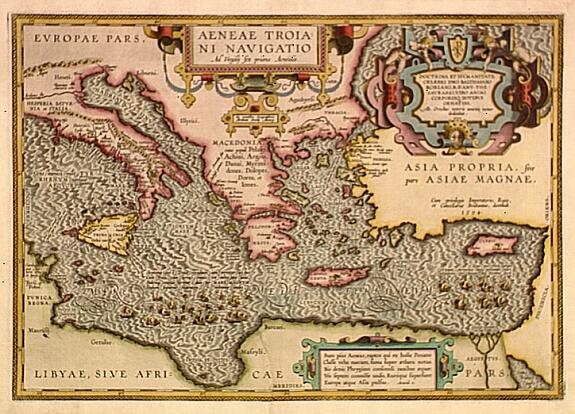 A
very unusual map by Ortelius. After the destruction of Troy, Aenaeas is reported
to have roamed the seas for seven years, as described in the writings of
Xenophon, Ovidius, Lycrophonous and with great detail by Virgilius in his
Aenaeas. In the course of there wanderings, only seven ships of the original
twenty remained. Depicted on this map [lower right side] are the seven ships.
Map covers areas of Italy, Greece and Cyprus. The condition is good, a repair of
a tear to the lower center fold is professionally done, strong impression,
original colors with an interesting cartouche in the upper right corner.The map
measures approximately (13.4" x 19.0").$
438.00 ($10.50 shipping/ handling/ ins.)
A
very unusual map by Ortelius. After the destruction of Troy, Aenaeas is reported
to have roamed the seas for seven years, as described in the writings of
Xenophon, Ovidius, Lycrophonous and with great detail by Virgilius in his
Aenaeas. In the course of there wanderings, only seven ships of the original
twenty remained. Depicted on this map [lower right side] are the seven ships.
Map covers areas of Italy, Greece and Cyprus. The condition is good, a repair of
a tear to the lower center fold is professionally done, strong impression,
original colors with an interesting cartouche in the upper right corner.The map
measures approximately (13.4" x 19.0").$
438.00 ($10.50 shipping/ handling/ ins.)
565.10 Tabula Ducatus Limburch et Comitatus Valkenburch in Lucem Edita A F. DeWit, c1795-1798, Johannes Covens & Corneille Mortier, Amsterdam
A detailed map by the printer/publishers Covens & Mortier of central Europe. The map is most likely to have come from DeWit’s Atlas Minor, 1670. Includes the City of Luyck and other French centers of population. Normal age toning and light foxing near the centerfold. Condition is very good; thin cut near the fold top, not visible unless viewed under glass. Measures approximately (21.5" x 18.2") with generous margins.$420.00 ($10.50 shipping/handling/ins.)
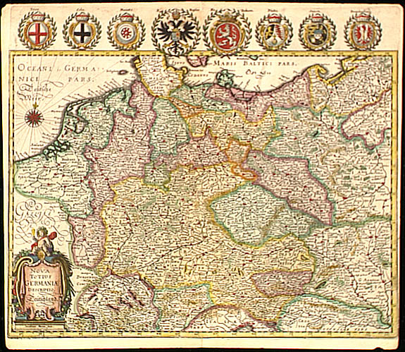
571.10 Nova Totius Germaniae, descriptio - Deutchland, Frankfurt, c1650, Matthaus Merian
520.2 Insulae Danicae, c1747, Johann Baptist Homann (Homann Heirs)
 This beautifully
engraved map of Denmark is a fine example of the German engraver Johann Baptist Homann
(1663-1724). Homann was a member of the Prussian Royal Academy of Science. After his death
in 1724 his family continued the business. This map was part of the Atlas Novus
first published in 1732. The map a very detailed cartouche at the bottom right. In
original colors. The map condition is very good, strong impression, very minor marginal
browning in lower left and right hand corners.Measures 19.5" x 22.9" . Map is
accompanied by a Certificate of Authenticity.$ 179. ($18.50
shipping/handling/insurance)
This beautifully
engraved map of Denmark is a fine example of the German engraver Johann Baptist Homann
(1663-1724). Homann was a member of the Prussian Royal Academy of Science. After his death
in 1724 his family continued the business. This map was part of the Atlas Novus
first published in 1732. The map a very detailed cartouche at the bottom right. In
original colors. The map condition is very good, strong impression, very minor marginal
browning in lower left and right hand corners.Measures 19.5" x 22.9" . Map is
accompanied by a Certificate of Authenticity.$ 179. ($18.50
shipping/handling/insurance)
570.13 Magnae Britanniae (General Map British Isles), c1749, Johann Baptist Homann (Homann Heirs)
 An excellent example of
Johann Baptist Homanns (1663-1724) work. After his death in 1724 his family continued the
publishing business. The map was part of the Atlas Novus first published in 1732.
Finely engraved and in original colors, the map includes a very detailed uncolored
cartouche. The map is in very good condition, strong impression, very minor foxing at the
lower left and right margins. Measures 22.4" x 19.0". Map is accompanied by a Certificate
of Authenticity.$ 210. ($18.50 shipping/handling/insurance)
An excellent example of
Johann Baptist Homanns (1663-1724) work. After his death in 1724 his family continued the
publishing business. The map was part of the Atlas Novus first published in 1732.
Finely engraved and in original colors, the map includes a very detailed uncolored
cartouche. The map is in very good condition, strong impression, very minor foxing at the
lower left and right margins. Measures 22.4" x 19.0". Map is accompanied by a Certificate
of Authenticity.$ 210. ($18.50 shipping/handling/insurance)
520.1 Comitatus Flandriae Nova Tabula, (1681-1697), D. Ioanni D’Hondt, Amsterdam
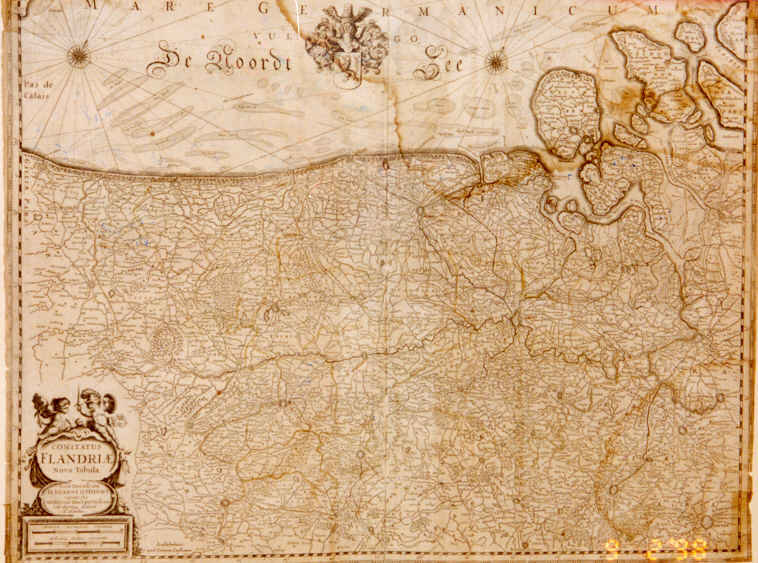 The map depicts northern Belgium (East Flanders) with very detailed
topography including the City of Ghent and parts of the Netherlands, North Sea. As a
decedent of one of Europe prominent cartographic families (Hondius), D’Hondt’s
work is an excellent example of 17th century cartography. Offered in a ornate
gold frame, double matte, non-asitic frame, under glass. Map 16.1" x 20.50",
very good (some water stain top left section, lt. foxing) $480. ($16.50
Shipping/Handling & Insurance)
The map depicts northern Belgium (East Flanders) with very detailed
topography including the City of Ghent and parts of the Netherlands, North Sea. As a
decedent of one of Europe prominent cartographic families (Hondius), D’Hondt’s
work is an excellent example of 17th century cartography. Offered in a ornate
gold frame, double matte, non-asitic frame, under glass. Map 16.1" x 20.50",
very good (some water stain top left section, lt. foxing) $480. ($16.50
Shipping/Handling & Insurance)
560.1 Nouvelle Charte DeL’Ocean Atlantique Et Thertre De La Guerre Tant En Europe Ou’en Amerque c1792, C.J. Chaumier, Paris
 This ornate chart compiled by C.J. Chaumier
(Theatre de la Guerre) is a fine representation of the engraver Louis Denis (1725-1794);
geographer to Duc de Berry. The chart contains embellishments around the title and the
typical light green tent along the coastlines. Chart 21" x 18.14"; very good
(center fold mark at the compass rose, lt. foxing), Paris $530.
($16.50Shipping/Handling & Insurance)
This ornate chart compiled by C.J. Chaumier
(Theatre de la Guerre) is a fine representation of the engraver Louis Denis (1725-1794);
geographer to Duc de Berry. The chart contains embellishments around the title and the
typical light green tent along the coastlines. Chart 21" x 18.14"; very good
(center fold mark at the compass rose, lt. foxing), Paris $530.
($16.50Shipping/Handling & Insurance)
560.12 World Map, Carto Universal En que se contiene todo lo que del mondo Se ha descubierto fasta agora, (Propoganda), Spain, , c1529, Diego Ribero
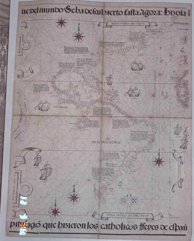 This magnificent map by the Portuguese [Lusitanian]
cartographer was drawn while he was in the service of Charles V of Spain at Seville. It is
a 19th century reproduction of the official map that was constantly updated by
Spain=s Pilot Major, whose duty it was to
interrogate returning navigators from their voyages throughout the known world. This map
is justifiably considered by many scholars to be the finest cartographic production of its
age. Ribero for many years was recognized as one of the most expert cosmographers of his
time. He was a personal friend of the Pilot Major, Sebastian Cabot; was the royal
cosmographer under Ferdinand Columbus; and made the maps which Magellan carried with him
on his famous voyage across the Pacific. Eventually, Ribero succeeded Cabot as Pilot
Major. The map covers the northern part of North America (on the coast of Greenland) and
extends down the east coast of North and South America, includes a portion of the west
coast of Africa and is the Spanish (text) version. Original colors, small tears at the
fold marks. Size: 33.0" x 80.0".$1140. ($26.50 s/h/ins.) Must be shipped
flat.
This magnificent map by the Portuguese [Lusitanian]
cartographer was drawn while he was in the service of Charles V of Spain at Seville. It is
a 19th century reproduction of the official map that was constantly updated by
Spain=s Pilot Major, whose duty it was to
interrogate returning navigators from their voyages throughout the known world. This map
is justifiably considered by many scholars to be the finest cartographic production of its
age. Ribero for many years was recognized as one of the most expert cosmographers of his
time. He was a personal friend of the Pilot Major, Sebastian Cabot; was the royal
cosmographer under Ferdinand Columbus; and made the maps which Magellan carried with him
on his famous voyage across the Pacific. Eventually, Ribero succeeded Cabot as Pilot
Major. The map covers the northern part of North America (on the coast of Greenland) and
extends down the east coast of North and South America, includes a portion of the west
coast of Africa and is the Spanish (text) version. Original colors, small tears at the
fold marks. Size: 33.0" x 80.0".$1140. ($26.50 s/h/ins.) Must be shipped
flat.
570.10 Accuratissima Galliae Tabula vulgo Royaume de France, Amsterdam, c1680, Frederick de Wit
570.12 Companiae Praefectura divisum in Electiones Rehemorum, Retlii...edentibus Gerardo, Amsterdam, c1709, Gerard Valk
 Original
color, is quite strong, as well as the impression itself. First appeared in the Atlas
Atlantis Sylloge Compendiosa (Amsterdam, G. Valk and P. Schenk , 1709), Phillips
Atlases #4276. Gerard Valk (1651-1726) and his son Leonard (1675-1755) were printers and
engravers in Amsterdam. In 1710 Leonard married into the Schenk family who ran one of the
most prosperous publishing houses in Amsterdam. The map covers much of the former
Champagne Province and parts of several others. Paris is at the center of the left margin.
Verden is near the right margin. The map is in very good condition, upper margin is close
at left corner, lower margin is close. Some staining; repair to edges outside the neat
line. Size: 23.6" x 19.2 Offered framed in a solid wood walnut finish, under glass
with non-ascitic matte board. $320. ($11.50 s/h/ins.)
Original
color, is quite strong, as well as the impression itself. First appeared in the Atlas
Atlantis Sylloge Compendiosa (Amsterdam, G. Valk and P. Schenk , 1709), Phillips
Atlases #4276. Gerard Valk (1651-1726) and his son Leonard (1675-1755) were printers and
engravers in Amsterdam. In 1710 Leonard married into the Schenk family who ran one of the
most prosperous publishing houses in Amsterdam. The map covers much of the former
Champagne Province and parts of several others. Paris is at the center of the left margin.
Verden is near the right margin. The map is in very good condition, upper margin is close
at left corner, lower margin is close. Some staining; repair to edges outside the neat
line. Size: 23.6" x 19.2 Offered framed in a solid wood walnut finish, under glass
with non-ascitic matte board. $320. ($11.50 s/h/ins.)
570.30 Carte Generale du bassin de Mer Noire, Russia, Frere A. Garnier, Paris, c1861
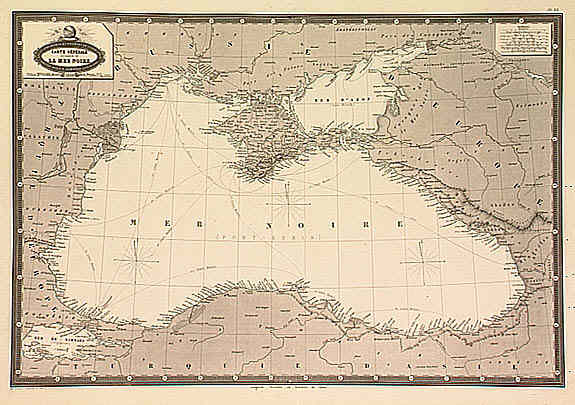 Very detailed map from the Atlas Sperodidal & Universel de
geographie, by F.A. Garnier and edited by Jules Renouard, rue de Tourno. Uncommon map
with decorative title cartouche right hand upper corner. Good detail of the Crimea and the
Black Sea. Size: 13.6" x 20.0 " $95. ($3.50 s/h/ins.)
Very detailed map from the Atlas Sperodidal & Universel de
geographie, by F.A. Garnier and edited by Jules Renouard, rue de Tourno. Uncommon map
with decorative title cartouche right hand upper corner. Good detail of the Crimea and the
Black Sea. Size: 13.6" x 20.0 " $95. ($3.50 s/h/ins.)
571.20 Northwest Spain, Legionis Regnum et Asturiarum Principatus, Spain, c1699, J. Blaeu/Jansson
 A very fine example of 17th century
cartography, in the original colors. First appeared in Blaeu’s Theatrum Orbis
Terrarum in 1635 and appeared again in the production of the Atlas Major in the
1660's. It also appeared in atlases by Jansson during the mid 17th century.
Joan [John] Blaeu, along with his father Willem Janszoon expanded the Atlas Major from
9 to ll vols., until the "great fire" of 1672 which destroyed his printing
house. Many of Bleau’s plates were sold in the 1670's, and many of his maps appeared
without text in atlases by Frederick de Wit (1630-1706). The map depicts Rivadeo (Ribadeo)
near the upper left and Loredo, the upper right, both along the coast of the Bay of
Biscay. Included is a portion of Portugal near the lower left. An interesting cartouche
embellishes the lower left corner. Wide margins, slight foxing, over all very good
condition. Size 14.8" x 18.9" offered framed in an appropriate solid wood,
non-ascitic matte board. $310. ($12.50 s/h/ins.)
A very fine example of 17th century
cartography, in the original colors. First appeared in Blaeu’s Theatrum Orbis
Terrarum in 1635 and appeared again in the production of the Atlas Major in the
1660's. It also appeared in atlases by Jansson during the mid 17th century.
Joan [John] Blaeu, along with his father Willem Janszoon expanded the Atlas Major from
9 to ll vols., until the "great fire" of 1672 which destroyed his printing
house. Many of Bleau’s plates were sold in the 1670's, and many of his maps appeared
without text in atlases by Frederick de Wit (1630-1706). The map depicts Rivadeo (Ribadeo)
near the upper left and Loredo, the upper right, both along the coast of the Bay of
Biscay. Included is a portion of Portugal near the lower left. An interesting cartouche
embellishes the lower left corner. Wide margins, slight foxing, over all very good
condition. Size 14.8" x 18.9" offered framed in an appropriate solid wood,
non-ascitic matte board. $310. ($12.50 s/h/ins.)
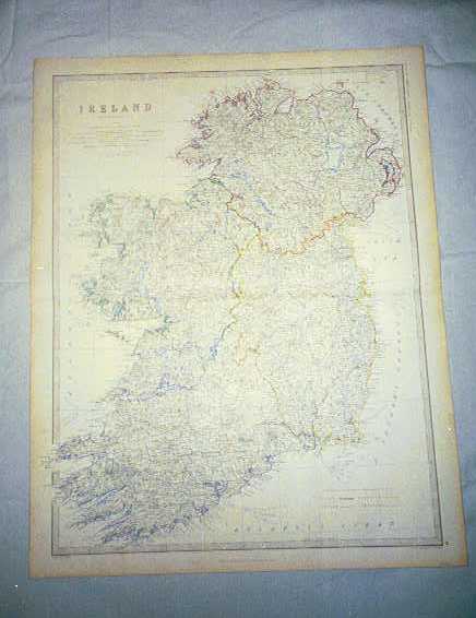
572.10 Ireland, c1855, by Keith Johnston
570.14 Atlas National Ilustre’ Departments....de la France (1845- 1864) by Victor Levasseur, Cartographer
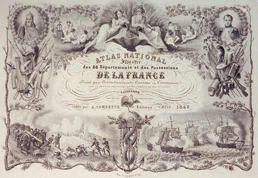
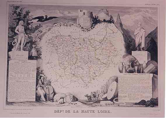
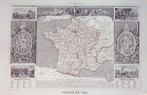
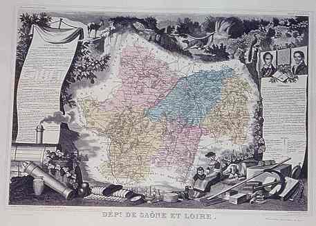
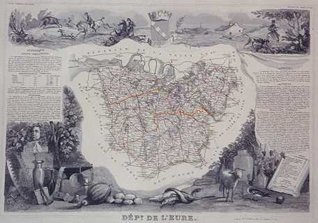
Victor Levasseur was a 19th century cartographer who produced a group of atlases that distinguished themselves with striking scenes of French history, countryside, products, (particularly geographic locations bearing the names of some of France’s finest wines), and other related activities indigenous to each "Department" illustrated. Each print is finely engraved, and printed on heavy rag paper. They are offered framed with the engraved portion of each measuring approximately 12.0" x 17.1" in printed area with larger margins provided. Each map is offered for $106. per copy complete with an appropriate solid wood ornate gold frame, double matted, and under glass. Each map is accompanied by our Certificate of Authenticity. Shipping, handling and insurance is an additional $18.00 per framed map. Unframed maps are also available for $ 48. each and $5.50 for shipping, etc. Each map listed is given it’s own condition rating, in keeping with our rating criteria found on the Home Page or in the catalog. Other specifics of the individual map offerings, i.e. color, special features, etc. are noted with each item:
570.141 Dept. des Bouches du Rhone, c1859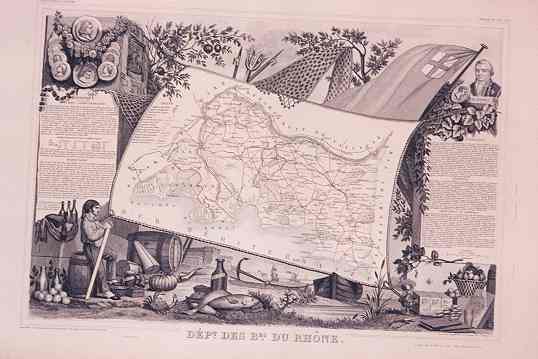
570.142 Dept. du Loiret, c1864
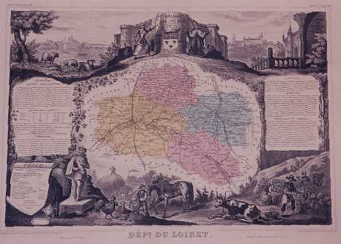 In original
colors, the map depicts Orleans, liberated from the English by Jeanne d’Arc who
appears in the top left portion of the decorative cartouche. Also, scenes of farms,
castles, and other topical french style scenes. Condition is very good
In original
colors, the map depicts Orleans, liberated from the English by Jeanne d’Arc who
appears in the top left portion of the decorative cartouche. Also, scenes of farms,
castles, and other topical french style scenes. Condition is very good
570.143 Dept. de la Haute Loire, c1846
570.144 France en 1850, c1856
570.145 Dept. De Saone et Loire, c1864
570.146 Dept. De la Meurthe, c1847 The map depicts Nancy near the center as part of the Province of Meurthe (now Meurthe-et-Moselle). Light color depicts the districts. Some fine vineyards are located in this region of France. Condition is very good.
570.147 Dept. De L’Eure, c1859
Back To Home Page