P.O. Box 570 · Fulton, Maryland 20759 · E-mail: Info@maps-charts.com · Call Toll Free 1-888-513-MAPS
P.O. Box 570 · Fulton, Maryland 20759 · E-mail: Info@maps-charts.com · Call Toll Free 1-888-513-MAPS |
|||||
|---|---|---|---|---|---|
| How to Purchase | Age of Exploration | Historical Maps | Europe | North/South America | Globes |
| Curency Conversion Table | Prints, Books Photos Misc | Retail Outlet | Whistler Prints | Hot Links | Home |
(Click on images to view in full page)
700.11 World Map, c1880, Paris, Louis Antoine
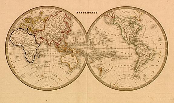 A very
fine 19th century print, double hemispheric world map with excellent geographic
names. In original colors, a good dark impression, natural age toning. Ideal for
framing and display. Condition is very good measures approximately (8.4" x
16.1").$ 179.00 ($10.50 shipping/ handling/ ins.)
A very
fine 19th century print, double hemispheric world map with excellent geographic
names. In original colors, a good dark impression, natural age toning. Ideal for
framing and display. Condition is very good measures approximately (8.4" x
16.1").$ 179.00 ($10.50 shipping/ handling/ ins.)
700.20 Wereld Kaart, na de Alderlaatste Ontdekking in"t Lieht gebragt, c1744, by Isaak Tirion
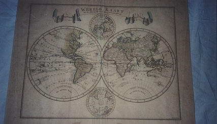 The
map is from the atlas of Isaak Tirion (1705-1769). A successful Dutch publisher
who produced extensive volumes of Dutch town plans and atlases. Tirion’ s only
world atlas Nieuwe en Boknopte Hand - Atlas, was published in six
editions dating from before 1740 to just after 1784. They contained from 34 to
100 maps in each atlas. This map from the 1744 issue is in very good condition,
some foxing and natural color change is noted with generous margins. However,
several stains are apparent at the bottom well outside the neat line. In
original colors, measures approximately (17.50" x 14.10").$
750.00 ($16.50 shipping/handling/ins.)
The
map is from the atlas of Isaak Tirion (1705-1769). A successful Dutch publisher
who produced extensive volumes of Dutch town plans and atlases. Tirion’ s only
world atlas Nieuwe en Boknopte Hand - Atlas, was published in six
editions dating from before 1740 to just after 1784. They contained from 34 to
100 maps in each atlas. This map from the 1744 issue is in very good condition,
some foxing and natural color change is noted with generous margins. However,
several stains are apparent at the bottom well outside the neat line. In
original colors, measures approximately (17.50" x 14.10").$
750.00 ($16.50 shipping/handling/ins.)
562.7 Chart of the Southern Hemisphere by Capt. James Cook c 1776
 Captain James R. N. Cook,
explorer, circumnavigator, hydrographer for His Majesty’s Navy, has provided the
cartographic world a treasurer trove of information from his voyages of exploration. This
particular rendering is apparently from his third voyage (1776-1779) with the various
tracks depicted. The engraved hemispherical map is arguably one of the most interesting
eighteenth-century renderings made of the expeditions. The spandrel design depicts the
tracks of the voyage along with geographic locations and their coordinates noted along the
side and bottom of the chart......chart is 21"h x 22"w; Very Good (small tear
right margin, lt. foxing); believed to have been part of one of the many atlases produced
from the voyages. $520. ($9.50 Shipping/Handling & Insurance)
Captain James R. N. Cook,
explorer, circumnavigator, hydrographer for His Majesty’s Navy, has provided the
cartographic world a treasurer trove of information from his voyages of exploration. This
particular rendering is apparently from his third voyage (1776-1779) with the various
tracks depicted. The engraved hemispherical map is arguably one of the most interesting
eighteenth-century renderings made of the expeditions. The spandrel design depicts the
tracks of the voyage along with geographic locations and their coordinates noted along the
side and bottom of the chart......chart is 21"h x 22"w; Very Good (small tear
right margin, lt. foxing); believed to have been part of one of the many atlases produced
from the voyages. $520. ($9.50 Shipping/Handling & Insurance)
12.00 Atlas Voyage au Polo Sud 1841-54
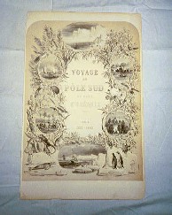
French aristocrat, Jules Sebastian Cesar [1790-1842], (Dumont D’Urville) was a navigator and geographer. He made significant contributions to the mapping of Australia, Antarctica, and the southern hemisphere. The prints and maps listed below are from his 1842 atlas Voyage au Polo Sud. Some selections are offered framed. Each print/map comes with a Certificate of Authenticity. Each print/ map condition is given (please see our Home Page for rating criteria).
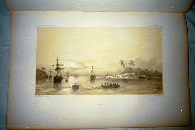
12.01 Voyage au Polo Sud, Rade de Banda, c1839, published [Gide Editeur] Paris
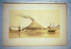 This striking print from the atlas
depicts the french fleet at anchor in the harbor near Hobart-Town. Fine detail of the
islands terrain and volcanic activity. Cesar’s exploits are brought into focus with
this impression (plate 113). The print image measures 16.1" x 9.0" with generous
borders. Overall condition is excellent. $ 90. ($5.50
shipping/handling/insurance)
This striking print from the atlas
depicts the french fleet at anchor in the harbor near Hobart-Town. Fine detail of the
islands terrain and volcanic activity. Cesar’s exploits are brought into focus with
this impression (plate 113). The print image measures 16.1" x 9.0" with generous
borders. Overall condition is excellent. $ 90. ($5.50
shipping/handling/insurance)
12.02 Voyage au Polo Sud, Viste au Sultan de Solo, c1839, published [Gide Editeur]
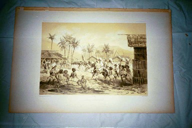 An unusual print of the Sultan of
Solo’s visit to Cesar’s camp. French troops are drawn up with warriors in
foreground and french officers in the background with the Sultan’s chiefs (plate
138). Highly detailed and interesting impression. Print measures 16.1" x 9.0"
with generous borders. Overall condition is excellent. $ 90. ($5.50
shipping/handling/insurance)
An unusual print of the Sultan of
Solo’s visit to Cesar’s camp. French troops are drawn up with warriors in
foreground and french officers in the background with the Sultan’s chiefs (plate
138). Highly detailed and interesting impression. Print measures 16.1" x 9.0"
with generous borders. Overall condition is excellent. $ 90. ($5.50
shipping/handling/insurance)
12.03 Voyage au Polo Sud, Havre-Dobo, c1839, published [Gide Editeur] Paris
 As the sun set over the South
Pacific, a long boat is in the foreground of this print (Plate 121) with the ships at
anchor and a spit of land jets out with the canoes of the natives in the background.
Overall condition is excellent. Print measures 16.1" x 9.0" with generous
borders. $ 90. ($5.50 shipping/handling/insurance)
As the sun set over the South
Pacific, a long boat is in the foreground of this print (Plate 121) with the ships at
anchor and a spit of land jets out with the canoes of the natives in the background.
Overall condition is excellent. Print measures 16.1" x 9.0" with generous
borders. $ 90. ($5.50 shipping/handling/insurance)
12.10 Voyage au Pole Sud, Hobart-town, c 1839
A print from the atlas of the Voyage au Pole Sud (plate 157). The navigator and geographer Jules Sebastian Cesar, (1790-1842) french aristocrat contributed to the knowledge and mapping of the southern continents, including Australia, New Zealand, and Antarctica. Double matted in solid ornate wood frame. Overall condition is excellent. Prints measures (includes frame) 20.3" x 17.50". $ 140. ($10.50 shipping/handling/insurance)
12.11 Voyage au Polo Sud, Hobart-town, c1839
A print from the atlas of the Voyage au Polo Sud (plate 158). The navigator and geographer Jules Sebastian Cesar, (1790-1842) french aristocrat contributed to the knowledge and mapping of the southern continents, including mapping of Australia, New Zealand, and Antarctica. Double matted in solid ornate wood frame. Overall condition is excellent. Print measures (including frame) 20.3" x 17.50". $ 140. ($10.50 shipping/handling/insurance)
12.15 Voyage au Pole Sud, Passage Antarctica, c1840
An unusual print from the atlas of the Voyage au Pole Sud (Plate 167). The navigator and geographer Jules Sebastian Cesar, (1790-1842) french aristocrat produced his atlas in Paris 1843. This print depicts natives aboard ship that he collected from the various islands he visited in the southern hemisphere. The print is dated January 19, 1840 at the South Pole. Double matted in a solid wood frame. Overall condition is very good. Print measures 23.10" x 22.75". $ 140. ($10.50 shipping/handling/insurance)
560.23 Voyage au Pole Sud, Carte, L’Ile Borneo, par D. J. Van Den Dungen Gronovius, Ingenieur Hydrographe de la Marine, c 1839
From the atlas of the Voyage au Pole Sud (carte 6). The navigator and geographer Jules Sebastian Cesar, (1790-1842) french aristocrat contributed much to the knowledge and mapping of the southern continents, including Australia, New Zealand, and Antarctica. $ 190. ($5.50 shipping/handling/insurance)
560.15 Voyage au Pole Sud, Antarctica, Carte, L’Astrolabe et La Zelee, Ingenieur Hydrographe de la Marine, c1841
An unusual print from the atlas of the Voyage au Pole Sud (carte VIII). The navigator and geographer Jules Sebastian Cesar, (1790-1842), french aristocrat produced his atlas in Paris, 1843. This map depicts the Vue de la cote Clarie and the track lines plotted. $ 210. ($5.50 shipping/handling/insurance)
700.40 World Map, c 1605, by Willem Jans Zoon Blaeu (facsimile)
Willem Jans Zoon Blaeu(1571-1638), cartographer, instrument maker, publisher and bookseller in Amsterdam; was the founder of his family's business. Born in Alkmaar, he produced the first sea atlas and in 1629 he bought 37 plates from Hondius (map maker) and issued the first land atlas in 1630. His 1605 map is considered to be one of his most acclaimed renderings. Offered here in gold foil and in full color, doubled matted in a solid wood frame. The life story of Blaeu beautifully embellishes the bottom of the map which measures (with frame) 23.0" x 32.0". A wonderful addition to the family room or office. $189. ($18. Shipping/handling/insurance)
700.10 La Mappe Monde World Map, dated 1816 This facsimile was produced in Spain and is one of the finest expressions of classical map making ever accomplished. It was the first map to show all of Capt. James Cook=s voyages and to incorporate the most recent discoveries in a clear and accurate manner. The map is the work of Eustache Herisson, hydrographer, geographer and a pupil of the famous mapmaker Rigobert Boenne (1727-1795). The solid wood frame is termed in 24k gold leaf with ornate cherry wood trim under glass. Measures 45.0" x 31.0" framed. $398. ($21.50 shipping/handling/insurance)