P.O. Box 570 · Fulton, Maryland 20759 · E-mail: Info@maps-charts.com · Call Toll Free 1-888-513-MAPS
P.O. Box 570 · Fulton, Maryland 20759 · E-mail: Info@maps-charts.com · Call Toll Free 1-888-513-MAPS |
|||||
|---|---|---|---|---|---|
| How to Purchase | Age of Exploration | Historical Maps | Europe | North/South America | Globes |
| Curency Conversion Table | Prints, Books Photos Misc | Retail Outlet | Whistler Prints | Hot Links | Home |
(Click on images to view in full page)
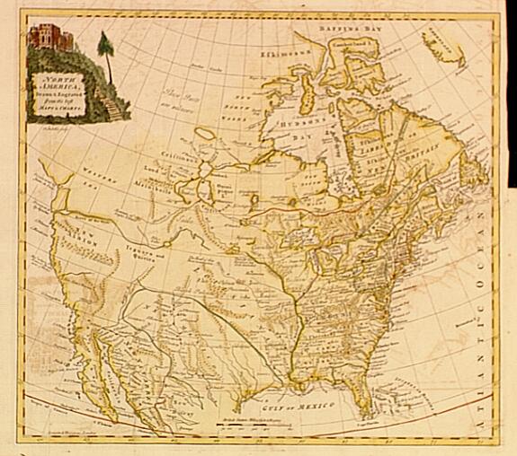
700.23 North America drawn and engraved from the best sources, c1777, Thomas Kitchin, London
 A
very detailed map of North America and the English colonies at the time of the
American Revolution. In original colors with an interesting cartouche upper left
corner.At the
time this map was produced the southern states - Virginia, North and South
Carolina, and Georgia made claim to all land west of the Mississippi. The maps
condition is good with a strong impression, some minor offsetting of text due to
oxidation of the ink. Upper right hand margin is cut close, small tear in that
area. The map measures approximately (13.1" x 14.6").$
320.00 ($10.50 shipping/handling/ins.)
A
very detailed map of North America and the English colonies at the time of the
American Revolution. In original colors with an interesting cartouche upper left
corner.At the
time this map was produced the southern states - Virginia, North and South
Carolina, and Georgia made claim to all land west of the Mississippi. The maps
condition is good with a strong impression, some minor offsetting of text due to
oxidation of the ink. Upper right hand margin is cut close, small tear in that
area. The map measures approximately (13.1" x 14.6").$
320.00 ($10.50 shipping/handling/ins.)
590.1 Map of Philadelphia, c1845, by Joseph Meyer, Amsterdam
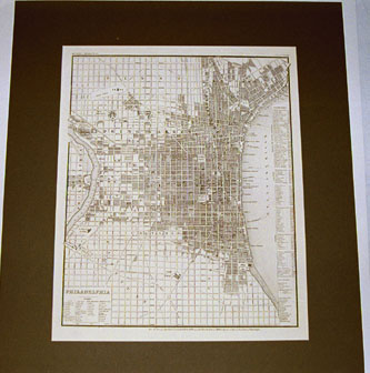 A very detailed street plan of the City of Philadelphia from the Meijers Hand
Atlas, published in Hildburghausen, Amsterdam, Paris, and Philadelphia. City Wards are
listed and major streets named. Franklin Square and Washington Square are highlighted.
Light foxing, good strong impression, and the map is rated in excellent condition. This
uncolored print measures approximately 14.75" x 11.80"$ 125. ($5.50
shipping/handling/insurance)
A very detailed street plan of the City of Philadelphia from the Meijers Hand
Atlas, published in Hildburghausen, Amsterdam, Paris, and Philadelphia. City Wards are
listed and major streets named. Franklin Square and Washington Square are highlighted.
Light foxing, good strong impression, and the map is rated in excellent condition. This
uncolored print measures approximately 14.75" x 11.80"$ 125. ($5.50
shipping/handling/insurance)
356.1 Portsmouth Harbor. USC&GS c1876
Visible on this chart are New Hampshire’s Three Bridges. Here the arm of the sea and the Piscataque River join. Included is a mosaic of tiny islands rich in history and charm. On Peirce Island is the revolutionary framework of Fort Washington. East of Seavy’s Island is the U.S. Navy Yard, heir to Portsmouth’s colonial shipbuilding industry...........chart is 21"h x 30"w; Very Good, published by the U.S. Coast & Geodetic Survey, Washington, D.C.; $146. ($3. S/h)
351.1 Boston Harbor c1856, U.S. Coast Survey, H.R. Hassler
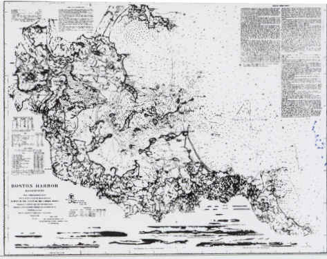 This is an
excellent example of 19th century cartography. Produced by the U.S. Coast Survey, the
large and attractive chart reveals the extent to which urban development had concentrated
in around the peninsula. Prominent at the bottom of the chart are "headland"
views of the approaches to the harbor. These include "entering Nantasket Roads",
"Boston Light", and "Broad Sound". Streets and surrounding communities
are noted such as Cambridge and Charlestown........chart is 32" h x 39"w; Good
condition (small tear just inside the neat line on the left), some foxing near the folds;
scale: 1:10,000; published by the U.S. Coast Survey, Washington, D.C $190. ($5.50
shipping/handling/ins.)
This is an
excellent example of 19th century cartography. Produced by the U.S. Coast Survey, the
large and attractive chart reveals the extent to which urban development had concentrated
in around the peninsula. Prominent at the bottom of the chart are "headland"
views of the approaches to the harbor. These include "entering Nantasket Roads",
"Boston Light", and "Broad Sound". Streets and surrounding communities
are noted such as Cambridge and Charlestown........chart is 32" h x 39"w; Good
condition (small tear just inside the neat line on the left), some foxing near the folds;
scale: 1:10,000; published by the U.S. Coast Survey, Washington, D.C $190. ($5.50
shipping/handling/ins.)
521.1 Patapsco River, c1859, by F.R. Hassler, U.S. Coast Survey
This exquisite mid 19th century nautical chart depicts one of Maryland’s most famous rivers. Included in this hydrographic chart is the harbor of Baltimore, with street patterns displayed. The chart covers the river to its entry way into the Chesapeake Bay. The chart is uncolored with light foxing, rated in very good condition, and measures approximately 18.50" x 28.00" with generous margins beyond the neat line. $ 110. ($5.50 shipping/handling/insurance)
971.3 Providence Harbor, Rhode Island, c1901, by U.S. Coast & Geodetic Survey
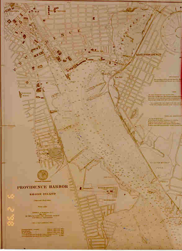 History is captured in this early
twentieth century nautical chart. Large scale projection provides fine detail of the
street plan for the lower portion of the city. Docking facilities and other navigational
information is included. The chart is uncolored, a small tear near the left border, some
foxing is noted. Overall the condition is rated good, with the chart measuring 16.00"
x 21.10". $42. ($5.50 shipping/handling/insurance)
History is captured in this early
twentieth century nautical chart. Large scale projection provides fine detail of the
street plan for the lower portion of the city. Docking facilities and other navigational
information is included. The chart is uncolored, a small tear near the left border, some
foxing is noted. Overall the condition is rated good, with the chart measuring 16.00"
x 21.10". $42. ($5.50 shipping/handling/insurance)
923.5 Entrance to San Diego Bay, c1851, by U.S. Coast Survey
This small but detailed hydrographic chart depicts the entry way to San Diego Bay. The chartlet contains a sidebar with sailing directions as well as soundings in the Bay. There is an insert depicting a sketch of the Bay at 1:100,000. The chart measures 12.50" x 13.0", condition is Good (some foxing and a small tear ouside the left neatline); scale: 1:25,000. $40. ($3.50 shipping/ handling & insurance)
573.00 Frederick County, Maryland, c1873
The following road maps published in 1873 of Frederick County, Maryland provide very detailed topographic information for this region of the United States. Surveyed by D.J. Lake, and published in atlas form by the C.O. Titus & Company; the maps offered are in color. Map sizes are approximately 24.12" x 22.75"; all in Very Good condition. Each map is priced at $50. ($3.50 s/h and insurance).
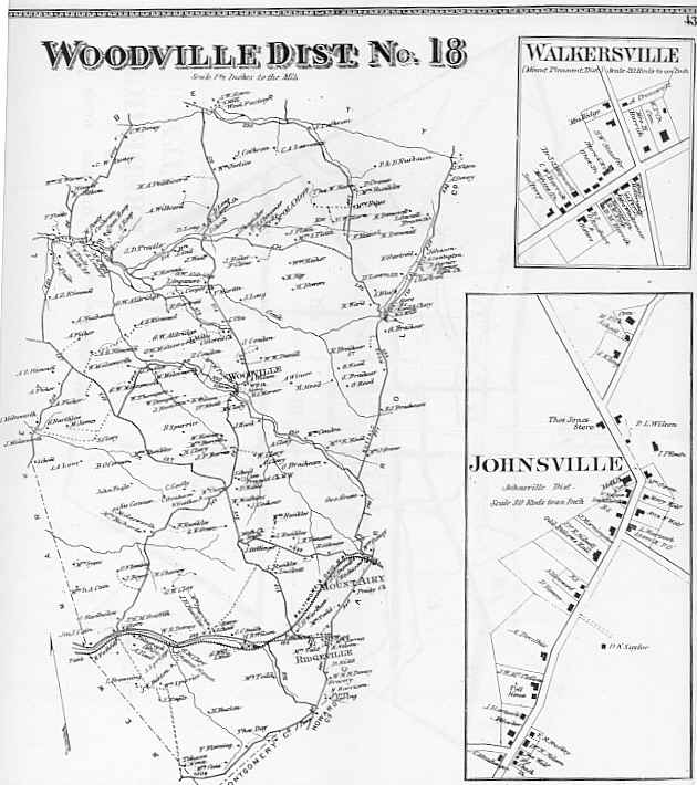 573.2 Woodville
District #18, Frederick, Md., c1873 - Plate 43, includes inserts of Walkersville
and Johnsville, Maryland. Property ownership and in some cases building locations are
provided.**Sold**
573.2 Woodville
District #18, Frederick, Md., c1873 - Plate 43, includes inserts of Walkersville
and Johnsville, Maryland. Property ownership and in some cases building locations are
provided.**Sold**
573.4 Emmittsburg District #5, Frederick, Md., c1873 - Very detailed topographic features, no details given beyond state line with Pennsylvania.
573.6 Woodsborough, District #11, Frederick, Md., c1873 - Depicts the village of Woodsborough, Frederick RR, and land owners of the time. **Sold**
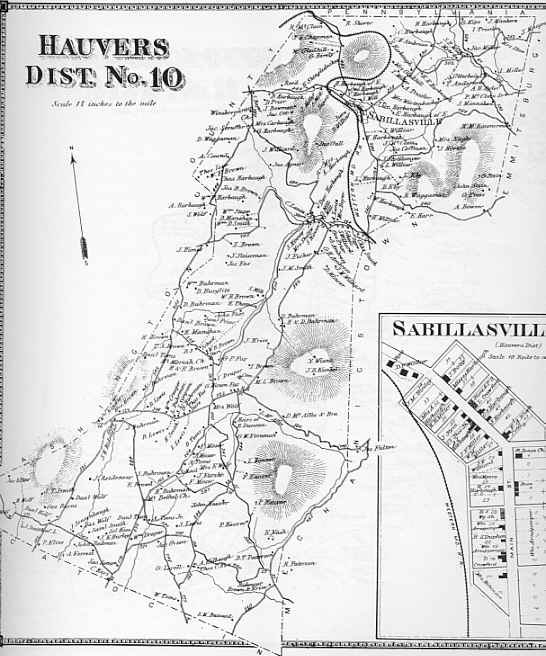 573.6 Hauvers,
District #10, Frederick, Md., c1873 - Includes insert of
Salbillaville street plan with shops named. **Sold**
573.6 Hauvers,
District #10, Frederick, Md., c1873 - Includes insert of
Salbillaville street plan with shops named. **Sold**
573.7 Johnsville, District #17, Frederick, Md., c1873 - Covers from Ladesburg in the northwest to Carroll County line in the southeast. Land owners names/farms are well covered in the geographic data provided.
573.8 Catoctan, District #6, Frederick, Md., c1873 - Depicts the town of Wolfsville with property names and roads indicated. **Sold**
573.9 Woodsborough, Graceham, Creagerstown, Frederick, Md., c1873 - Detailed street plan of Woodsborough with two additional villages shown with street names and stores identified.
573.10 Mechanicstown, District #15, Frederick, Md., c1873 - Detailed geographic data on land/farm ownership with shaded relief of the Catoctin Mountains. The Maryland R.R. is also depicted.
360.3 Map of New York Bay and Harbor, c1845, U.S. Coast Survey
A good pictorial image of the early growth of New York City and its environs is depicted in this nautical chart. The only real concentration of urban development evident is on Manhattan Island and Newark. Includes Oyster Bay and a headland view of Sand Point Light.....chart is 24.0" x 34.0", Fair condition (small tear on the east side of the map near Oyster Bay, some foxing at folds), scale: 1:80,000; published by the U.S. Coast Survey, A.D. Bache.$965. ($4.50 s/h and insurance)
360.1 Long Island Sound, c1855, U.S. Coast Survey
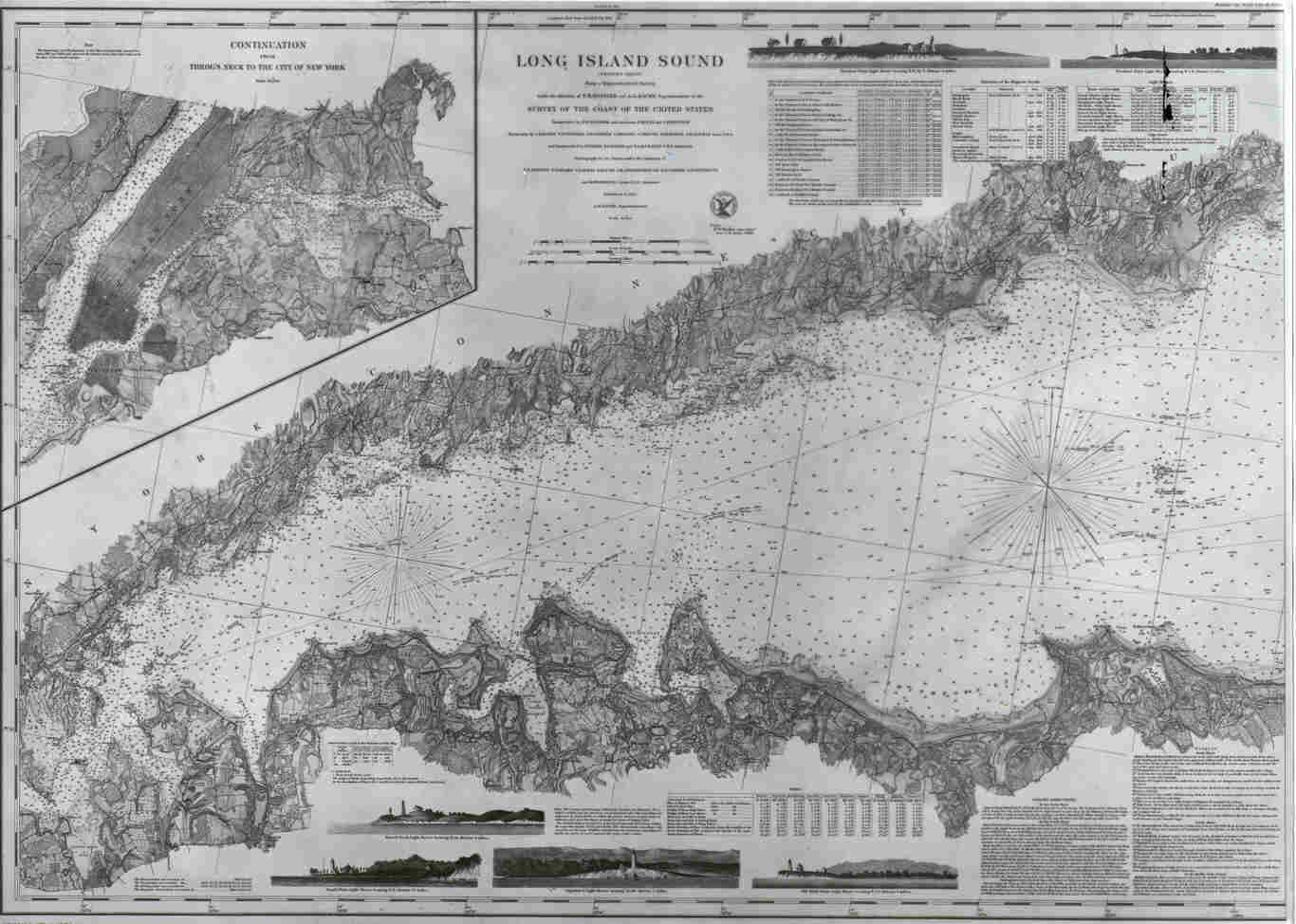 As captured in
this mid 19th century nautical chart, Long Island had already had considerable
growth. Its exploration and colonizing spans over several centuries from Henry
Hudson’s voyage in 1609 for the Dutch East India Company, to England’s force of
arms in 1664, til its colonial development and birth as a major seaport. The chart
includes detailed topographic information including Manhattan Island, Brooklyn, and
headland views of Sand Point Light, Eaton’s Head Light and Captain’s
Light........chart is 24.75" x 35.0", good condition (some foxing around edges),
scale: 1:80,000; published by the U.S. Coast Survey, H.R. Hassler, Washington, D.C.
$468. ($4.50 s/h and insurance)
As captured in
this mid 19th century nautical chart, Long Island had already had considerable
growth. Its exploration and colonizing spans over several centuries from Henry
Hudson’s voyage in 1609 for the Dutch East India Company, to England’s force of
arms in 1664, til its colonial development and birth as a major seaport. The chart
includes detailed topographic information including Manhattan Island, Brooklyn, and
headland views of Sand Point Light, Eaton’s Head Light and Captain’s
Light........chart is 24.75" x 35.0", good condition (some foxing around edges),
scale: 1:80,000; published by the U.S. Coast Survey, H.R. Hassler, Washington, D.C.
$468. ($4.50 s/h and insurance)
360.5 New York City and Environs, 1860, U.S. Coast Survey
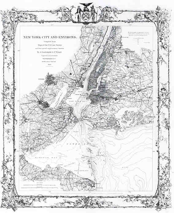 This very detailed map of the
City of New York as "entered according to an Act of Congress in the year 1852 by A.
Lindenkohl & P. Witzel in the clerks office of the District Govt. Of the Southern
District of New York" is at a scale of 1:200,000. Includes topographic and
hydrographic features as well as areas of Newark and Elizabeth, New Jersey, map is
26.2" x 23.7"; condition is Very Good; published by Westermann & Co., New
York, with cartographic information provided by the Westerman &
Company, New York. $430. ($4.50 s/h and
insurance)
This very detailed map of the
City of New York as "entered according to an Act of Congress in the year 1852 by A.
Lindenkohl & P. Witzel in the clerks office of the District Govt. Of the Southern
District of New York" is at a scale of 1:200,000. Includes topographic and
hydrographic features as well as areas of Newark and Elizabeth, New Jersey, map is
26.2" x 23.7"; condition is Very Good; published by Westermann & Co., New
York, with cartographic information provided by the Westerman &
Company, New York. $430. ($4.50 s/h and
insurance)
923.7 San Antonio Creek, California, c1857, A.D. Bache, Survey of the Coast
 An unusal hydrographic chart
combining both soundings in the eastern section of San Francisco Bay and topographic
features of the town. Complied by Cmdr. James Alden, USN, Assist USCS and at a scale of
1:20,000. Chart measures 14.75" x 20.0"; condition Very Good; Long & Laing
Litho Co., New York, Survey of the Coast, Treasury Dept. $48. ($3.50 s/h and
Inusrance)
An unusal hydrographic chart
combining both soundings in the eastern section of San Francisco Bay and topographic
features of the town. Complied by Cmdr. James Alden, USN, Assist USCS and at a scale of
1:20,000. Chart measures 14.75" x 20.0"; condition Very Good; Long & Laing
Litho Co., New York, Survey of the Coast, Treasury Dept. $48. ($3.50 s/h and
Inusrance)
560.2 Map of Mexico, Central America and the West Indies, c1866, by Samuel Augustus Mitchell
A wonderful example of 19th century cartography. This hand colored map provides great detail of Mexico, Central America as well as the West Indies with numerous place names provided. It includes four insets: Map of Cuba, Island of Jamaica, Bermuda Island, and an interest inset of the Panama Railroad. A fine example of Mitchell’s work as one of Philadelphia’s major map/atlas publishers. Decorative border with some light foxing noted and centerfold with double paper reenforcing, several small tears outside the neat line. The overall condition is rated very good. The map measures approximately 13.10" x 21.10" $ 110. ($5.50 shipping/handling/insurance)***SOLD***
700.14 North America, c1677, Giovanni Giocomo de Rossi, Rome (facsimile)
This reproduction of a 17th century Rossi map was originally a French map published in 1669 by the Nicholas Sanson family. It shows California as an island with much of the northeast out of scale. The map measures 18.7" x 23.7" and is offered framed in a gold tone solid wood frame, double matted, and under glass. A fine addition to any home or office. $ 195.00 ($36.50 shipping/handling/ins.)
600.10 U.S. Territories Public Survey, c1941, by B.F. Bartle & Co., Washington, D.C.
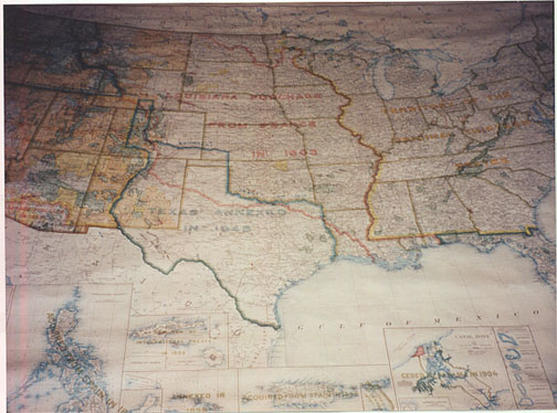 This very large wall map of the United States and territories was prepared by
the U.S. Dept. Of the Interior and includes data on the original thirteen (territories),
the Louisiana Purchase of 1803, the Texas annexation of 1845, Alaska and Hawaii as of
1898, the Canal Zone 1904, and the Oregon Territory of 1846. Also depicted are the
National Parks as of 1941, monuments, Indian Territories, game reservations, national
forests, railroads and canal barge routes. The map is in full color and mounted on a wood
roller. Overall condition is excellent, cloth backed and measures approximately
5'.22" x 7'. 18". $ 230. (Special handling costs will apply depending on
shipping location)
This very large wall map of the United States and territories was prepared by
the U.S. Dept. Of the Interior and includes data on the original thirteen (territories),
the Louisiana Purchase of 1803, the Texas annexation of 1845, Alaska and Hawaii as of
1898, the Canal Zone 1904, and the Oregon Territory of 1846. Also depicted are the
National Parks as of 1941, monuments, Indian Territories, game reservations, national
forests, railroads and canal barge routes. The map is in full color and mounted on a wood
roller. Overall condition is excellent, cloth backed and measures approximately
5'.22" x 7'. 18". $ 230. (Special handling costs will apply depending on
shipping location)